Rod Hollow Shelter
The turnoff for Rod Hollow shelter is located about 3.6 miles north of US 50 and 3.7 miles south of VA 605 (Morgans Mill Rd), in the trail section known as the "Roller Coaster". The shelter is about 0.1 mile west off the trail. The blue trail leading to the shelter has a big muddy patch and a stream crossing bridged with loosely placed tree trunks. We pass this shelter during the VA AT #4 hike, and typically have lunch here. There is one two-level lean-to structure with a small fire circle in front of it. There is also a covered picnic table with a stone fire grill. A signed trail leads to the privy a short distance beyond the shelter. Another signed trail leads to a gushing piped spring.
Built 1986
Next shelter NB: Sam Moore shelter, 6.9 miles
Next shelter SB: Whiskey Hollow/Dicks Dome shelters, 8.5 miles
Distance - 8.3 mi
Time - 4:14
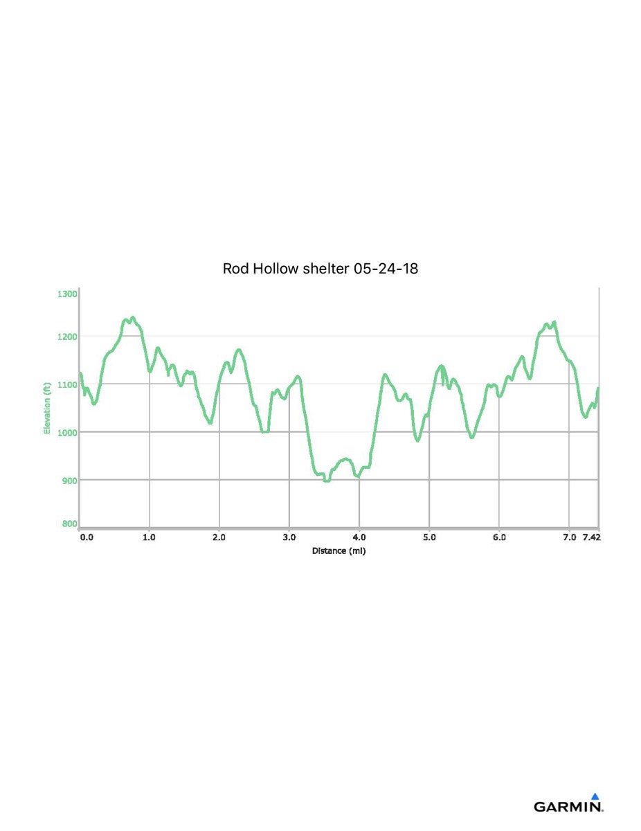
Total Ascent - 1470 ft
Total Descent - 1508 ft
Max Elevation - 1244 ft
Min Elevation - 897 ft
I parked at the Ashby Gap trailhead parking, Rt 601, just north of US 50, and walked along the blue trail to the AT, then north along the trail to the shelter. There were several challenging stream crossing on this "Roller Coaster" section of the AT. New photography online shows a newly-constructed footbridge. I don't know whether it is on the AT or on the shelter approach path. Need to revisit!
Built 1986
Next shelter NB: Sam Moore shelter, 6.9 miles
Next shelter SB: Whiskey Hollow/Dicks Dome shelters, 8.5 miles
Distance - 8.3 mi
Time - 4:14
Total Ascent - 1470 ft
Total Descent - 1508 ft
Max Elevation - 1244 ft
Min Elevation - 897 ft
I parked at the Ashby Gap trailhead parking, Rt 601, just north of US 50, and walked along the blue trail to the AT, then north along the trail to the shelter. There were several challenging stream crossing on this "Roller Coaster" section of the AT. New photography online shows a newly-constructed footbridge. I don't know whether it is on the AT or on the shelter approach path. Need to revisit!