Manassas Gap Shelter
The turnoff for Manassas Gap shelter is located about 2.3 miles north of the Tucker Lane (VA 725) parking area. The shelter is about 100 yards east off the trail. We pass this shelter during the VA AT #6 hike and usually have lunch here. There is one lean-to structure with a picnic table, several benches and a fire ring. Along the entrance trail there are several tent spaces and a bear pole. The privy is located a short distance beyond the shelter. A trail in front of the shelter leads a short distance downhill to a piped spring.
Built 1933 by CCC
Next shelter NB: Whiskey Hollow/Dicks Dome shelters, 4.4 miles
Next shelter SB: Jim & Molly Denton shelter, 5.5 miles
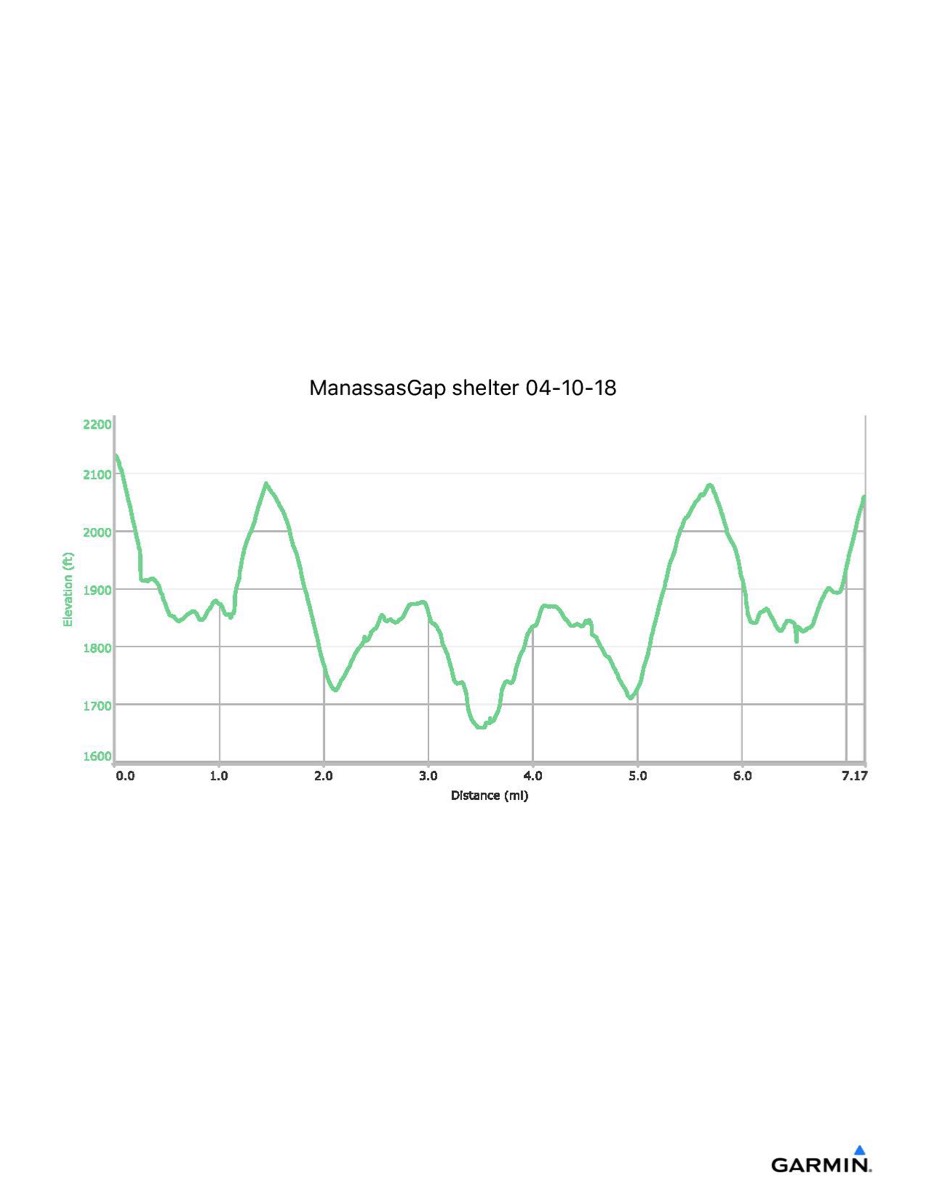
Distance - 7.2 mi
Time - 3:52
Total Ascent - 1376 ft
Total Descent - 1447 ft
Max Elevation - 2135 ft
Min Elevation - 1659 ft
note: this track data was extracted from the combined hike here and to Whiskey Hollow/Dicks Dome shelters. The numbers may not be exact.
I parked at Freezeland Road (VA 638) and walked along the blue trail to the AT, then south along the trail to the shelter. I also visited Whiskey Hollow shelter and Dicks Dome shelter on this outing. This parking area has since been closed off and a future visit would have to begin from the Ridge parking area a short distance to the north of this lot.
Built 1933 by CCC
Next shelter NB: Whiskey Hollow/Dicks Dome shelters, 4.4 miles
Next shelter SB: Jim & Molly Denton shelter, 5.5 miles
Distance - 7.2 mi
Time - 3:52
Total Ascent - 1376 ft
Total Descent - 1447 ft
Max Elevation - 2135 ft
Min Elevation - 1659 ft
note: this track data was extracted from the combined hike here and to Whiskey Hollow/Dicks Dome shelters. The numbers may not be exact.
I parked at Freezeland Road (VA 638) and walked along the blue trail to the AT, then south along the trail to the shelter. I also visited Whiskey Hollow shelter and Dicks Dome shelter on this outing. This parking area has since been closed off and a future visit would have to begin from the Ridge parking area a short distance to the north of this lot.