James Fry Shelter at Tagg Run
The turnoff for James Fry shelter is located 1.4 miles south of PA Rt 34, and the shelter is 0.2 miles uphill on a side trail. We pass this shelter during the PA AT #5 hike. Because it comes so early in the hike, we only stop here for a short break and take lunch further along the trail. There is one shelter building, with a picnic table in front of it and another table a short distance uphill. There is signage to a privy behind the shelter. There is also signage to a spring further uphill from the picnic table, but that spring is unreliable and was dry when I was there. Most people were getting water directly from Tagg Run at one of several access points along the AT near the shelter turnoff.
Next shelter NB: Alec Kennedy shelter, 8.1 miles (not included in this collection)
Next shelter SB: Toms Run shelter, 11.1 miles
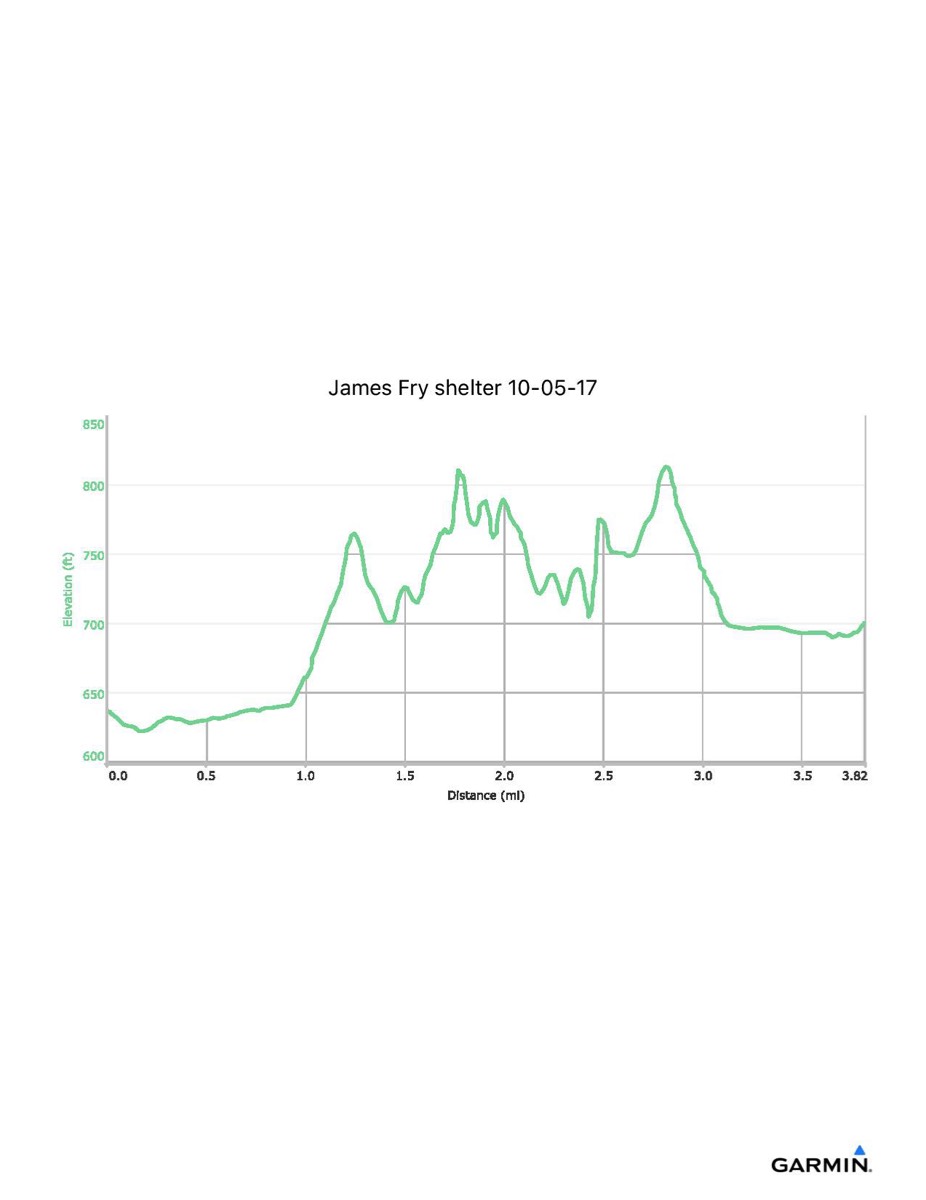
Distance - 3.8 mi
Time - 1:44
Total Ascent - 505 ft
Total Descent - 439 ft
Max Elevation - 815 ft
Min Elevation - 622 ft
I parked at the PA Rt 34 AT parking area and walked North along Rt 34 to the point where the AT crosses the road, then turned south along the AT to the shelter. Returning, I took the blazed shortcut directly from the AT to the parking area. Note that this track data was extracted from a longer hike when I was scouting for the PA #5 hike, so the distances and elevation profile may be a bit off.
Next shelter NB: Alec Kennedy shelter, 8.1 miles (not included in this collection)
Next shelter SB: Toms Run shelter, 11.1 miles
Distance - 3.8 mi
Time - 1:44
Total Ascent - 505 ft
Total Descent - 439 ft
Max Elevation - 815 ft
Min Elevation - 622 ft
I parked at the PA Rt 34 AT parking area and walked North along Rt 34 to the point where the AT crosses the road, then turned south along the AT to the shelter. Returning, I took the blazed shortcut directly from the AT to the parking area. Note that this track data was extracted from a longer hike when I was scouting for the PA #5 hike, so the distances and elevation profile may be a bit off.